A survey of the Island's archaeology was carried out in the late 1970's and published by the County Council (Basford 1980). Since the archaeological implication reports for the Cowes and Ryde District Plans have been prepared by the County Archaeological Unit on behalf of Medina Borough Council and published in limited numbers by the Planning department. These reports are profusely illustrated and of great interest.
The Island has been occupied since the Old Stone Age and has a number of historic monuments and archaeological sites well worth a visit. The location of the past settlement and burial sites was often determined by the underlying geology so an understanding of the local geology is important.
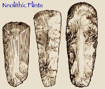
No visible sites of the Palaeolithic (old stone age) and Mesolithic (middle stone age) exist, but flint implements from these periods are included in the Carisbrooke Castle museum. The Longstone near Mottistone which is situated on the greeensand south of the central chalk spine running from the Needles to Culver Cliff, is one of the only three surviving field monuments of the Neolithic (new stone age) on the Island. The other two monuments are a long barrow on Afton Down and a 'mortuary enclosure' on Tennyson Down. Other than these three sites the only evidence for local Neolithic activity consists of flint implements which are found mainly in ploughed fields on the greensand and along the river valley's and some fragments of pottery which have been found beneath Bronze Age burial mounds.
One of these sites near Gatcombe where a peat bog exists was recently examined by Dr. R. G. Scaife of the Institute of Archaeology who, after excavating a trench, was able to date the Neolithic layer to c.3000 B.C. from plant remains. This palynological report has been published in the Hampshire Field Club Proceedings.
Archaeologists think that the Longstone was an earthen long barrow (burial mound) with a stone revetted entrance. The actual burial mound is now very insignificant but the two large blocks of local green sand - one upright and one lying on the ground - which are the remains of the entrance façade, are still very impressive. The Longstone is presumably named after the large upright stone. The recumbent stone beside it is reported to have been moved from its original nearby position by a nineteenth century squire who was anxious to see what lay underneath it (but didn't find anything). A small excavation which was carried out at the Longstone in 1956 did not locate any burials. Access to the Longstone is from Mottistone village via the signposted footpath (no. 43) next to Mottistone Manor.
The Island has many bronze age burial mounds known as round barrows. Over 240 sites have been reported, nearly all of them on the chalk down; some of the mounds have been completely ploughed away and others are covered with trees. One plough-damaged barrow on the Gallibury Down was totally excavated during 1979-80. Material from the graves and pits beneath the mound was used for radio carbon dating, these dates were found to range between 1600 B.C. to 1400 B.C. At least eighteen ring ditches (the remains of barrows) were discovered in the Wellow/Thorley area in 1977 from the air as crop marks. All these ring ditches situated on the Bembridge Limestone are clearly visible on aerial photographs but there is nothing to see on the ground. One of these rings was partially excavated during August 1984 by the County Archaeological Unit and it is thought that this barrow may have been plough damaged in the Iron Age or Roman times.
The groups of barrows described below are unploughed examples on permanent grassland and have survived in fairly good condition, but most of them have suffered from the activities of medieval barrow robbers or early nineteenth century excavators as the large craters in the centre of many of these mounds testify.
This consists of four visible barrows, mutilated by early excavators and rabbit burrows, and eroded by human feet. One of these barrows, known as Harboro Barrow, contains the foundations of war-time building. Access is from the National Trust car park at map ref. SZ. 420845.
This group is marked as 'five barrows' on the 1:50,000 ordnance survey map, but in fact there are eight mounds. Three different types of round barrow are represented in the group. Six of the mounds are bowl barrows which are the most common type of round barrow, consisting of a simple mound with or without a ditch. In addition, however, there is one bell barrow and one disc barrow. For a description of the different types of round barrows see Collins Field Guide to Archaeology. Access to the site is from the road from Brook to Shalcombe at SZ 395851. Take the marked Bridleway No. 53. After a steep climb up the brook, go down for half a mile (up to the right of the track) where the barrows are situated on the highest point of the down, near the Ordnance Survey trig. point.
There are ten visible barrows, several with central hollows and one mutilated by an army trench. Two barrows on Ashey Down were excavated in 1969. The excavation report contains a plan of Ashey Down which shows the position of a prehistoric field system, a medieval stock enclosure and several medieval 'pillow' mounds - earthworks which are thought to be artificial rabbit warrens (Drewett, 1970). The general area of the barrows are at map reference SZ 571876, via footpath number 24 to Ashey Seamark, however part of the route is not a public right of way.
The only major Iron Age monument on the Island is Chillerton Down Hill Fort and a visit to the site is difficult due to problems of access. However three Roman Villa sites have produced late Iron Age pottery, which suggests a continuity of occupation from pre-Roman times.
At least seven Roman villas are known on the Island. Newport and Brading Villas are open to the public, Newport having an extremely well preserved bath house and hypocaust while Brading possesses some fine mosaics. Note the use of local materials such as Bembridge limestone roof slabs and flint, limestone, greensand and chalk used on the walls. At Brading Villa a field system can be seen nearby Brading Down. The remains of field-systems associated with the villa can be seen as low banks or lynchets. The chalk downland were cultivated in prehistoric and Roman times because the light chalk soil was not too difficult to plough.
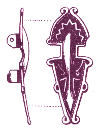
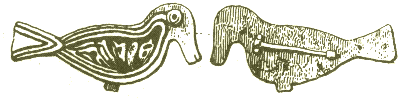
Little archaeological evidence has survived of the Jutish invaders who came to the Island in post Roman times. The two main sites are cemeteries at Chessell Down and Bowcombe Down. There are no visible remains at either of these sites but both were excavated in the nineteenth century. They produced (in addition to skeletons) iron swords, knives and jewellery such as brooches and buckles. The biggest brooches are now in the British Museum but some swords, parts of shields, small brooches and buckles are retained in the county archaeological centre.
The most important medieval monument to the Island is Carisbrooke Castle. The site on which the Castle stands has been used for defensive purposes since pre-Norman times. The remains of the stone fortification, almost certainly of late Saxon date, underlie the earthworks of the castle and can be seen incorporated in the banks. The castle has a typical Norman moat and bailey layout which dates from the early twelfth century and probably replaced smaller temporary fortifications thrown up after the conquest. Carisbrooke, with its moat and shell keep, its curtain wall, its well-defended gatehouse and medieval domestic buildings (now housing the museum) is an excellent example of a medieval castle. Other notable features are the Elizabethan outer fortifications and the well-house with its donkey wheel for drawing water. Carisbrooke Castle also has association with Charles 1, who was imprisoned there during the Civil War, and relics of his imprisonment are displayed in the museum.
Newtown was laid out by a Bishop of Winchester and his ecclesiastical estate at Swainston and was granted Borough status in 1256. However, the 'New town' did not prosper, partly because it was in competition with existing towns and ports at Yarmouth, Newport and Southampton, and partly because of the extensive damage it suffered during French raids in the fourteenth century. Despite Newtown's failure as a town (it had dwindled to a small hamlet in the sixteenth century) it was given parliamentary representation by Elizabeth 1 and acquired a town hall in the late seventeenth century. The unique interests of Newtown lies in the fact that the street pattern of the medieval town survives intact and unchanged, although several of the streets are merely grassy lanes. In addition, a number of the individual plots of ground laid out in the thirteenth century, to accommodate the houses and gardens of prospective tenants, are still visible as tiny enclosed fields. There is an eighteenth century estate map reproduced by the National trust, available at the National trust shop in Newport or Newtown Town hall. There is also a quay with two rectangular ponds by the boathouse. These are salterns - the last surviving remains of the once thriving salt industry which existed here until the late nineteenth century.
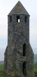
A reminder of the peril to shipping caused by the exposed southern coast of the Island is provided by the medieval lighthouse on St. Catherine's Hill, known locally as 'The pepperpot' (see picture). The lighthouse and also an adjoining oratory (chapel) - now vanished - was built by Walter D Godeton in the early fourteenth century and it is now the second oldest lighthouse in Britain (the eldest being of Roman vintage at Dover). To visit the lighthouse take the footpath from the car park just inland from Blackgang. Whilst walking up St Catherine's Hill, notice the medieval cultivation terraces and strip lynchets. These strip lynchets, evidence of ploughing, can be seen on many hill slopes throughout Britain and demonstrate the scarcity of land in the Middle Ages, which made it necessary to take much more marginal land into cultivation. On reaching the lighthouse note the distinctive roofline on one side of the building where once the vanished chapel was joined onto the lighthouse. Note also the enclosing turf wall around the lighthouse which is probably contemporary with the building and is shown on the Elizabethan survey of the area. Near to the lighthouse is a Bronze Age barrow, which was excavated in 1925. South of the medieval lighthouse there is a later lighthouse commenced in 1785 but never completed. This building is known locally as the 'salt pot'. St. Catherine's Hill was not a very suitable place for a lighthouse since it is frequently obscured by mist. The present day lighthouse - built shortly after the wreck of the Clarendon in 1837, is situated on the coast at the foot of the Undercliff, just to the west of Niton.
The threat of invasion to the Island did not end with the Norman Conquest. There were French raids throughout the Middle Ages and in the sixteenth century. It was because of the threat of French raids that Henry VIII built forts at Sandown, East & West Cowes, and Yarmouth. Of these forts, remains survive only at:
There is little to see at West Cowes, where the small amount of Henrican work that survives is incorporated into the Royal Yacht Squadron building.
Yarmouth Castle is substantially intact and is a good example of a Tudor fortification. The castle is under Department of Environment guardianship and is open to the public. The most recent military remains on the Island (other than a few late nineteenth century forts and remains of gun emplacements of the two world wars) date back to the 1860's when a series of forts were placed around the coast as a deterrent to the new French iron-clad ships.
Good examples of forts which can be viewed from the outside, although not open to the public, include Fort Albert, Golden Hill, Sandown Granite Fort and Bembridge Fort. Puckpool Battery is in a public park just outside Ryde. No Man's Land Fort can be seen from the ferry or Hovercraft from Ryde. Horse Sand Fort and Spitbank Fort, which were constructed on artificial Islands in the Spithead Channel, form part of the mid-nineteenth century defensive system.